Reading Time – 5 minutes, Difficulty Level 1/5
Alfred Russel Wallace was a 19th century natural historian. Well known for having envisaged the process of evolution independent of his contemporary Charles Darwin, Wallace’s studies of wildlife across the Amazonian rainforest and Indonesian archipelago made him a pioneering figure in the study of how geography affects animal distribution.

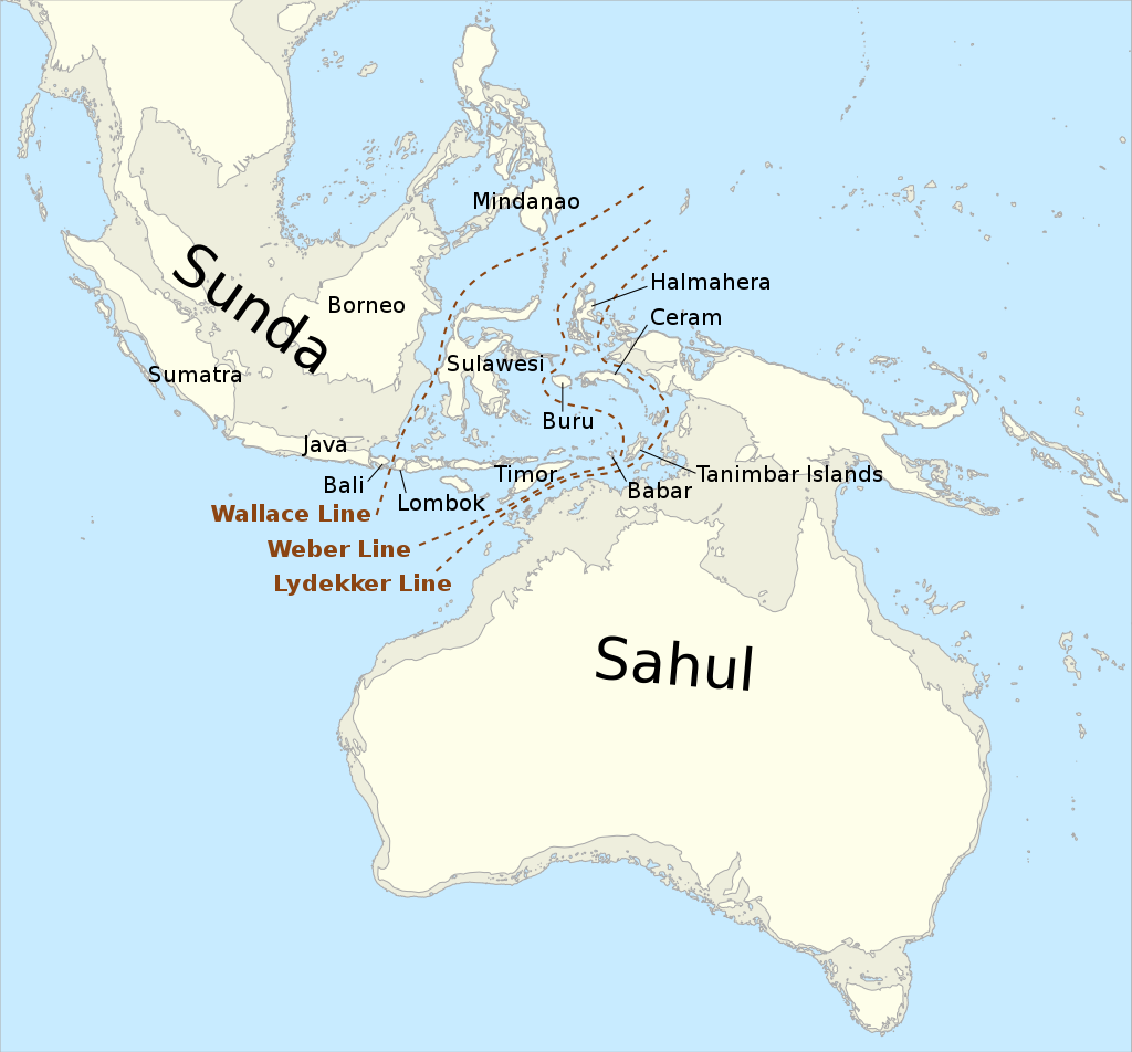
During his time in Indonesia, Wallace observed a peculiar division in animal life. A clear and sudden change in the faunal content of Indonesia’s many islands seemed to occur across an invisible border. Through analysis of the distribution of species, both by Wallace and other scientists, a line was drawn that illustrates this divide that splits Indonesia down the middle from north to south. It was named the Wallace Line by Thomas Henry Huxley in honour of its discoverer.
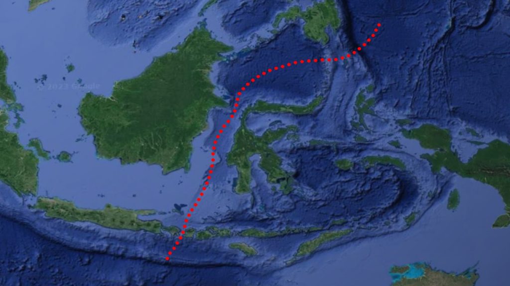
To the west of the line, one can find animals associated with the Asian mainland such as elephants, big cats, hoofed mammals and primates. To the east, the wildlife becomes more distinctly Australasian, including a great diversity of marsupials, monotremes, cockatoos and ratites (large flightless birds like Emus and Cassowaries).
Overlap between these two populations is extremely limited, mainly limited to the isle of Sulawesi where Babirusa and Black-Crested Macaque live alongside Cockatoos and Cuscus. Only one species of terrestrial mammal, the Crab-Eating Macaque, can be found on both sides of the Wallace Line.
There is nowhere in Indonesia where, for example, Tree Kangaroos coexist with Tigers, or Orangutans with Echidnas, despite the distance between islands being only around 35 km. Elsewhere in the world far greater distances have been crossed by animals either by swimming or in rafting events, so why is there such a difference in wildlife across such a small barrier of water?
The answer may lie in Indonesia’s ancient geography.

When viewing a map of tectonic plates, the vast chunks of Earth’s crust which drift and move across its molten mantle, Indonesia is revealed to be a veritable jigsaw of small, highly active plates competing for space amongst the three larger continental shelves; the Eurasian, Philippine and Australian plates. The Wallace line seems to fit quite neatly along one of the fault lines that border these plates. The sea along this fault line can average depths of 250 m, compared to the adjacent waters on the Eurasian plate that average just 46 m. This creates a boundary of deep waters, strong currents and high winds, blocking passage to all but the most powerful swimmers. The water is so deep that it has held its position for thousands of years.
During the ice age, large volumes of water were sealed away in the colossal ice sheets that dominated the northern hemisphere, causing a drop in global sea levels. Areas that we today recognize as island chains were connected as single land masses, but the strait of water that defines the Wallace Line was still very much in place.
For millennia, organisms on either side of the boundary evolved in isolation to one another. Whole ecosystems completely unique from one another, and yet separated by only the tiniest natural boundary.
Wallace’s discoveries opened a whole new field of biogeography, exploring how geographical features, whether they be modern, ancient, visible or hidden, affect the distribution of living things, which helped start a new chapter in our understanding of the tremendous complexity which defines the natural world.
Further Reading
On The Physical Geography Of The Maley Archipelago – Alfred Russell Wallace
Evolution: The History Of An Idea – Peter J Bowler
Evolution, Biogeography, and Maps: An Early History of Wallace’s Line – Jane R. Camerini
A lifelong natural history enthusiast, Dane has built an online following recreating prehistoric life through animation, & is now studying for a Natural Sciences degree while participating in STEM ambassadorship & climate activism.